- Join
- Mar 21, 2018
- Messages
- 22
- Age
- 60
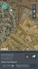
In the pics posted there are 2 advisories with the same airport. As you can see from pic I’m clearly out of the 5 mile radius of the airport (no tower). At times it’s onlt one advisory with a ceiling of 400’.
I have no intention of flying over what it says not to but I’m not understanding the contradiction here.
I have no intention of flying over what it says not to but I’m not understanding the contradiction here.