Welcome DJI Spark Pilot!
Jump in and join our free Spark community today!
Sign up

AutoPilot and the Spark

Tom
Thanks for all the valuable tips at the beginning of this thread and throughout. I have been watching this thread for a while now and trying out the various flight modes. I purchased AP for the ability to do Waypoints and 360 panos on the Spark. Up until getting AP, I had flown my Spark with Litchi 80% of the time and GO4 20%. Since Waypoints are not supported in Litchi on the Spark, I decided to try AP out - I love it! It adds so many features to the Spark.

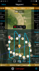
Waypoints - the ability to fly curved paths and have waypoint actions is great. In Litchi Waypoints (doesn't work on Spark) you cannot have curved paths and waypoint actions at the same time. Also, there are many more possible actions in AP.

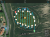
360º Pano mode - I had trouble getting this to work on the Spark since the gimbal only pitches down to 85º. But after trying out a number of settings in the custom mode I was able to get the pano mode to work (Vertical - Start 0º, Vertical - End -85º). Have not tried other pano modes yet but when the weather gets better I will.

Panos on GO4 are convenient - all of the images are arranged in separate folders which is a nice touch and you have the ability to preview a low-res version of the pano to see if it worked. I take a lot of panos and although GO4 does a great job, I like the ability in AP to mark a location for the pano and have the Spark fly there and take the pano. I also love being able to take 360º panos on waypoint missions. As far as I know, this is not possible on any other flight software (GO4 or Litchi) on any of the DJI drones without using AP. As far as assembling panos, I always do it in PTGui or Photoshop anyway regardless of which flight software I use.

Chris
 
Hi,

i could need some help. I would like to use the spark for creating maps.
I used waypoint mode in AP for it.
I allready created some waypoint missions and the spark flew it perfectly.
But i cant find the images on the SD card (enough free space on it 10GB+).
I tried every wayponit mode in AP: mapping with basic, intermediate or advanced mode.
What have i done wrong? Attached you will find my settings in AP.

Thanks for the help in advanced.

Greetings from germany
 

Attachments

  • IMG_0950.PNG
    IMG_0950.PNG
    6.4 MB · Views: 29
  • IMG_0951.jpg
    IMG_0951.jpg
    1.5 MB · Views: 27
I recall having some difficulty with "map" mode in getting the camera to activate automatically as expected. I plan to work on it some more as soon as the weather and wind clear up a bit.
 
I got some missions under my belt. the first couple waypoint missions went awesome. The next few, it seemed like my spark lost its calibration. But even after recalibrating it would go the start point for the waypoint mission but seem like it was trying to figure which direction to go. Even do as much as rock back and forth like the wind was too strong but the wind was minimal. That's the best way I can explain it. After reading some of the others that have used AP and watching some youtube videos I was wondering if maybe my setup of the mission the spark is maybe trying to aim the gimbal in a way that the spark is not capable of doing. Or maybe trying to yaw (if that is the correct phrasing) in a way that the spark can't do. Plus I know a big issue is I am still learning the fundamentals of it all. Are some of the features in AP not spark compatible? Also, any other advice would be appreciated.
 
I recommend that you write a note to their tech support and see what they have to say about the behavior. I had a similar thing happen once on an orbit mission. I wrote and got an answer but I can't say I clear understood the answer, and unfortunately I discarded the note.....(won't let that happen again.) As I recall, they said something about the relative altitudes. Since then, I have made double sure that when I take off, the take off altitude is correct. It has helped so far and I have not had a repeat so far. I had the same rocking and the camera would not stay on target when usually it is rock solid.

I have found that not every feature of the app works with the Spark. You have to go slowly and learn what works and what does not. I my opinion, some things are best done using the DJGo4 app. Other things are best done using the AP app. There are so many features....pick the ones that you really need and practice with them until you are really good...then move on to others.
 
I got some missions under my belt. the first couple waypoint missions went awesome. The next few, it seemed like my spark lost its calibration. But even after recalibrating it would go the start point for the waypoint mission but seem like it was trying to figure which direction to go. Even do as much as rock back and forth like the wind was too strong but the wind was minimal. That's the best way I can explain it. After reading some of the others that have used AP and watching some youtube videos I was wondering if maybe my setup of the mission the spark is maybe trying to aim the gimbal in a way that the spark is not capable of doing. Or maybe trying to yaw (if that is the correct phrasing) in a way that the spark can't do. Plus I know a big issue is I am still learning the fundamentals of it all. Are some of the features in AP not spark compatible? Also, any other advice would be appreciated.
I had something similar happen on one of my Waypoint missions that I had flown many times - the camera didn't seem to know which focus subject to point at and kept rotating back and forth. It eventually stopped and continued the mission but when I landed there was a dead bug on the sensor area right next to the camera lens. I cleaned it up and have not had any problems since so I am wondering if the bug messed up the sensor and caused the camera to get confused.
 
Hi,

i could need some help. I would like to use the spark for creating maps.
I used waypoint mode in AP for it.
I allready created some waypoint missions and the spark flew it perfectly.
But i cant find the images on the SD card (enough free space on it 10GB+).
I tried every wayponit mode in AP: mapping with basic, intermediate or advanced mode.
What have i done wrong? Attached you will find my settings in AP.

Thanks for the help in advanced.

Greetings from germany
I tried the mapping mode today for the first time and although the Spark flew the designated flight path no images were taken, so I will be looking into this as well.

One thing I have noticed is that when I use the Spark for Spherical panos (both 360 and 180) I have to use a custom profile and set the gimbal so that the Vertical End is -85º to get it to work. When I ran the mapping mission, I chose Spark as the camera and noticed the Camera Angle was -84º (the default) and no photos were taken, so I am going to try it again when I get a chance and change the Angle to -85º since that works for Spherical panos.

What I have noticed with AP is that it is very picky about correct gimbal settings so if a setting is not correct it will not complete the mission and will just hover in place. I wonder if the incorrect gimbal setting is what is causing the mapping not to work. Once, I get a chance to try again with the gimbal set at -85º, I'll report back with my results.

Chris
 
I went out this afternoon and flew three flights, two with AP. It was too windy to try a mapping mission so I just flew a couple of old waypoint missions that I had previously saved. On one mission, I clicked the icon in the bottom right to pull up the "live options" that are available. While it was flying, I tried changing the focus method. I had it set to "joystick" which I really like. I changed it to "device" and back several times. Then I changed it to "touch" and the spark lost it's mind. The camera started jostling all around. I think I did not define my touch target well enough. So, I aborted the mission using my custom abort button and full control was NOT restored as usual. Control was sluggish and incomplete. So... I clicked it into sport mode and the program crashed but I DID regain full control and flew it in for a nice landing in my hand. Since I had the spark in sight at all times, there was no panic.

I decided that it is not wise to fiddle with "touch" mode on a windy day and in the middle of a mission.
 
So today i tried another mapping test. I saw that addvice of Chrislaf and set the gimbal to 85°. But this didnt work neither. What i found out is that the spark will take picture during waypoint mode if you touch the camera button on your RC or the little white spot in the camera screen in AP (look at the picture below, the red button). But i dont understand how it works. So far i understand that you can change between different photo modes e.g. Burst, Single, RAW Burst and so on. If you touch the button it will change to a red button on the screen which says: 3/10s. I dont know what that means. Photos will be taken for more then 10sec. On my little waypoint mission i had to pull the trigger 3 times. Maybe anyone can use this information to solve finally the problem.
 

Attachments

  • IMG_9098.PNG
    IMG_9098.PNG
    1.6 MB · Views: 23
I re-tried my mapping mission today with the gimbal set at -85º. It flew the path perfectly, got a camera trigger message as soon as it started the mapping and during the mapping I looked at the camera view, it was pointing where is was supposed to, and the camera had been automatically set to interval shooting, and there was another camera trigger message when it was done, BUT there were no pictures taken. I guess I'll email Hangar and see if they have any ideas.
 
Anyone know if it is possible to stack several waypoints above each other?

The idea would be to make an acent and use AP's possibility to smoothly turn around at the same time. E. g. a filming cork screw. In the MODed app it does not work with waypoints closer than 5 meters I think it was. Don't know if that is only with horizontal distance or if the same with AP.

Would be nice if anyone have some experience, as the forecast here is too windy for a couple was before I can test myself.
 
I re-tried my mapping mission today with the gimbal set at -85º. It flew the path perfectly, got a camera trigger message as soon as it started the mapping and during the mapping I looked at the camera view, it was pointing where is was supposed to, and the camera had been automatically set to interval shooting, and there was another camera trigger message when it was done, BUT there were no pictures taken. I guess I'll email Hangar and see if they have any ideas.

I don't think that the Spark supports "interval shooting"..... So even though the APP may report that interval photo are being taken, they are not because the Spark does not support this feature. I wish it did. Personally, I do not use Video hardly at all.... only photos. So it would be a real help if the Spark would simpy take a photo every X number of seconds... but there is no such feature. I think the the AP app was designed for all the drones so there are some features that simply do not work with the spark.

A word from their tech support on this subject would be nice.
According to the Spark Specs on DJIs website, the Spark does support interval shooting. It is listed in the ‘Stiil Shooting Modes’.

I have fired off an emsil to their tech support but so far no response.

I too mostly take photos but being able to use waypoints has got me more interested in video since I can get more stable shots that way.

Chris
 
Today I went out again to try shooting a mapping mission. I used my same mission as before but just changed a few things and tested each time. I flew 4 missions (all 4 of my batteries). I had SUCCESS on my 3rd mission - the Spark took photos! Finally! The 4th mission flew the path but again no pictures were taken.

Here's what I did for the successful mission: I set the gimbal to the default -84º, Ground Sample Reference to 'Capture Angle' (not sure if this makes any difference), and height to 22m. Once I started the motors I went into the photo menu (interval is automatically chosen for mapping) and set the interval to 2s and the number of shots to 150. I then engaged the mission and once the Spark got to the first boundary point the interval shooting began (the camera button changed from white to red) and the Spark flew noticeably different. It flew ahead a bit tilted down quickly then flew ahead again, rotated a bit, tilted down again, etc. I am sure glad I had my battery clip on because the movements are fast and sharp so if the battery was not snug this would certainly jiggle it free. When the mission completed the Spark was still taking some interval shots so I manually stopped it. The Spark took 143 images and 7 more while idling at the end point.

The fourth mission was not successful likely because I changed the interval to 4s and 60 shots. When I looked up the Spark Specs it only supports intervals at 2/3/5/7/10/15/20/30/60s, so my setting to 4s is likely why it didn't work.

What I have observed about AutoPilot is that the settings in any mode must match what the AC is capable of. I had a similar problem with panos not working initially because the defaults are for Aircraft with 3 axis gimbals that can tilt down 90º. I still have lots of trial and error left to do to figure out exactly what works for the mapping missions.

Regardless, it's pretty amazing what can be done with this software. It adds many features that are not supported on the GO4 app. This is similar to what Litchi does for the Phantom 3 Standard. Thank God for 3rd party developers!

Chris

Congrats on the success of mission 3. I will definitely try it.

The specs on the spark vs what is said in the manual seem to differ or I am just missing something. As you stated, the spec DOES list interval shooting, but when you look up shooting modes in the DJIGo4 manual, it is never mentioned and so far, I have not seen a way to activate it using their Go4 app. What am I missing.

I'll try using your setup on mission 3.... thanks.
Thanks for the congrats and good luck on your try. Let us know how it goes.

When I did look in GO4 before running the AutoPilot mapping mission, I was able to select interval but couldn't figure out how to select the interval time. I usually only use GO4 for the pano modes if not using AutoPilot. Before getting AutoPilot, I would use Litchi 99% of the time and it was easy to select the interval shooting and the interval.
 
A short question about the camera. When flying AP, how is it possible to make manual settings so the exposure matches the darker parts instead of automatic?
 
Chris, great job on figuring out the mapping feature. Though I have no real usage of creating maps, I‘ll definitely give it a try in the next 2 weeks with my Spark and Mavic Air.

Cheers

Pete
 
Chris, great job on figuring out the mapping feature. Though I have no real usage of creating maps, I‘ll definitely give it a try in the next 2 weeks with my Spark and Mavic Air.

Cheers

Pete
Thanks. I really don’t have a use for maps either but I was curious about what the maps would look like. I ran it through a trial copy of Agisoft PhotoScan and was able to create a rudimentry map from my small mission. The map has a 3D look to it so if you were flying over mountainous terrain I can see how this would give a unique perspective. Plus being able to create your own 3D maps is pretty cool especially on the Spark.
Chris
 

New Posts

Members online

No members online now.

Forum statistics

Threads
14,600
Messages
118,820
Members
18,007
Latest member
Leahandran